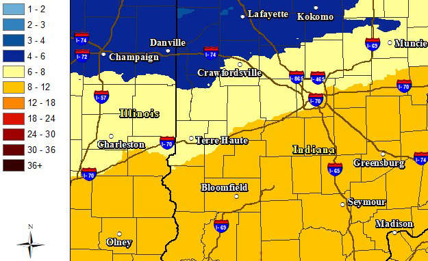
SOUTH-CENTRAL, Ind. - The National Weather Service (NWS) has announced that it has issued a Winter Storm Warning for a good portion of Indiana this weekend.
The Winter Storm Warning will be in effect from noon on Saturday until 7 p.m. on Sunday and was issued for south-central, west-central, east-central, southwest, southeast, and central Indiana. Travel will be very challenging.
In addition, the National Weather Service issued a Cold Weather Advisory from Friday at 7 p.m. until tomorrow at 10 a.m.
The impacted area includes Bartholomew, Johnson, Jackson, Jennings, Brown, Decatur, and Shelby Counties.
Heavy snow is expected, with possible accumulations ranging from 8 to 12 inches.
The heaviest snowfall is predicted for late Saturday night through early Sunday afternoon in south-central Indiana. During the period, NWS meteorologists forecast a 70% probability for 6+ inches of snow and a 60% chance of 8+ inches
In addition to the snow, south-central Indiana will face extremely cold temperatures beginning Friday. Thermometer readings will be in the teens most of the day and single digits by nightfall. At times, wind chills will be -10 and lower. The freeze continues through Monday with highs in the teens and lows near zero.
 Columbus City Council gives final approval for $3M TIF grant for Crump Theatre project
 City of Columbus adopts 2027 municipal budget
 Bartholomew County Historical Society holds 'A Bite of History' tour
 Apply now for 2 Heritage Fund-Bartholomew County music scholarships
 Columbus police to upgrade shooting range, purchase new patrol car
 Spears Street (near Fairgrounds, Southside Elementary) closes starting Oct. 9
 North Vernon woman drives donuts on courthouse lawn
 Visit Columbus announces $14,000 in available tourism grant funds